Maps made easy

Map examples

All map examples were generated with our plugin. Most examples can be imported directly to your plugin. A download button can be found at the end of each example page.

Custom Crop for Europe, Africa and Middle East

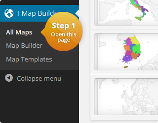
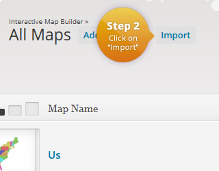
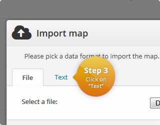
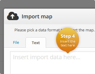
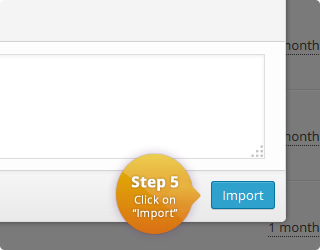
This is a custom crop of the world map which shows only Europe, Northern Africa and the Middle East. If you want to use the custom crop with one of your maps, you can simply import the map by using the download button below. If you already created a map, you can copy the HTML and CSS of map template of this map over to your existing map. If you have problems with this, please let us know and we will help you.

Please also note that the custom crop is not useful for all maps. It is possible that tooltips will get cut off if they are are located close to the left side.

The map configuration can be seen here:

Continue reading

How to Show only Africa

This is an interactive map of Africa without showing the other continents:

The default map of Africa shows all surrounding continents. To hide all of them, you will an additional CSS rule. If you want to add it to an existing map, then follow these steps:

  1. Open your map in the map builder
  2. Click on “Map Template”.
  3. Append the following CSS to your existing styles:
    #{cssid} svg g:nth-child(1) > g:nth-child(1) > path:nth-child(n+1):nth-child(-n+518) {
      display: none;
    }
    
  4. Click on “Update Preview” to see the changes.

This will manually hide all elements within the SVG graphic that belong to the other continents. If you haven’t created a map yet, you skip the steps from above and import the following:

Name Value Description
Region Africa List with all available regions
Width auto Width of the map in pixel. 'Auto' means that the map is centered in the available width.
Height 350 Height of the map in pixel. 'Auto' means that the map is centered in the available height.
Display mode Regions Specifies the display mode of the map.
Border resolution Countries The resolution of the map borders.
Tooltips On Allows to display a tooltip for highlighted map elements.
Tooltips: Trigger focus The user interaction that causes the tooltip to be displayed.
Tooltips: Use HTML Off Specifies if the tooltips should use HTML. This allows to customize the tooltips even more. For example, if this property is on, it is possible to display images wihtin the tooltip.
CSS
#{cssid} {
 
}
#{cssid} svg g:nth-child(1) > g:nth-child(1) > path:nth-child(n+1):nth-child(-n+518) {
  display: none;
}
HTML
<div id="{cssid}">
  %%map%%
</div>

JavaScript

Executed when a marker/region is clicked.

Click value can be defined for each map element.

Color Name Click Value
Empty table

Interactive Map of Africa

This is an interactive map of Africa showing some Portuguese speaking countries:

The plugin allows to edit a given region simply by clicking on a country. In this example we decided to color all countries that speak at least partly Portuguese. It is also possible to set a different focus. For example, there are also maps for Eastern, Southern, Western, Northern and Middle Africa.

Continue reading

Search

Responsive? Yes!

Our maps are fully responsive. They automatically fit into the available width. Try it by resizing your browser window.

Did you know…

  • All examples are importable to your plugin.
  • We extend our set of examples from time to time. If you think there is an example missing, write us a message and we will try to add it!

User reviews

  • Best map-plugin I could find.
  • Great support. Real fast response. This was exactly what I needed. Very flexible and useful.
  • Was waiting for plugin like this for ages! Customer support is also great.
  • Customer support is excellent and very quick. I have no hesitation in recommending this product.

Example for a sidebar map


All maps can also easily be added to your sidebar.