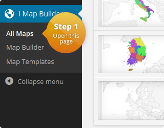
This is an interactive map of Ireland:
The plugin allows to edit the color and tooltip for a given region. This example has customized HTML tooltips. If you compare them to the default tooltips, you will notice that these have round corners and a different padding in the inside.
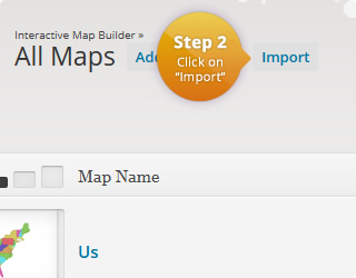
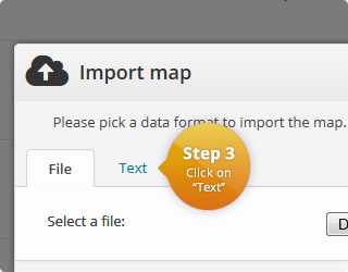
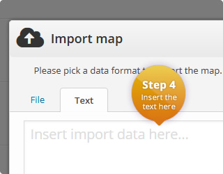
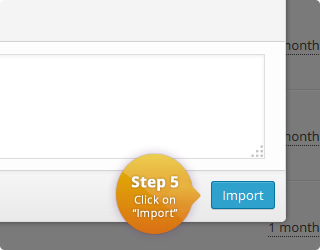
To get the same tooltips, you can either import this map (click on the download button below) or add the following lines to the CSS of the map template:
#{cssid} .google-visualization-tooltip {
  border-radius: 20px;
}
#{cssid} .google-visualization-tooltip-item {
  padding: 0 15px;
}
Please note that you have to make sure that “HTML Tooltips” are enabled in the tooltip box.
If you need another tooltip styling, contact us and we will try to help you!
The map of Ireland can be split into the following regions:
- Carlow
- Cavan
- Clare
- Cork
- Donegal
- Dublin
- Galway
- Kerry
- Kildare
- Kilkenny
- Laois
- Leitrim
- Limerick
- Longford
- Louth
- Mayo
- Meath
- Monaghan
- Offaly
- Roscommon
- Sligo
- Tipperary
- Waterford
- Westmeath
- Wexford
- Wicklow
The map configuration can be found here:
| Name | Value | Description |
|---|---|---|
| Region | Ireland | List with all available regions |
| Width | auto | Width of the map in pixel. 'Auto' means that the map is centered in the available width. |
| Height | auto | Height of the map in pixel. 'Auto' means that the map is centered in the available height. |
| Display mode | Regions | Specifies the display mode of the map. |
| Border resolution | Provinces | The resolution of the map borders. |
| Tooltips | On | Allows to display a tooltip for highlighted map elements. |
| Tooltips: Trigger | focus | The user interaction that causes the tooltip to be displayed. |
| Tooltips: Use HTML | On | Specifies if the tooltips should use HTML. This allows to customize the tooltips even more. For example, if this property is on, it is possible to display images wihtin the tooltip. |
| CSS | #{cssid} .google-visualization-tooltip {
border-radius: 20px;
}
#{cssid} .google-visualization-tooltip-item {
padding: 0 15px;
} |
|
| HTML | <div id="{cssid}">
%%map%%
</div> |
|
|
JavaScript Executed when a marker/region is clicked. Click value can be defined for each map element. |
||
| Color | Name | Click Value |
|---|---|---|
| IE-DL | ||
| IE-LM | ||
| IE-CN | ||
| IE-MN | ||
| IE-LH | ||
| IE-SO | ||
| IE-MO | ||
| IE-RN | ||
| IE-LD | ||
| IE-WH | ||
| IE-MH | ||
| IE-G | ||
| IE-D | ||
| IE-CE | ||
| IE-TA | ||
| IE-OY | ||
| IE-LS | ||
| IE-KE | ||
| IE-WW | ||
| IE-KK | ||
| IE-CW | ||
| IE-WX | ||
| IE-LK | ||
| IE-WD | ||
| IE-CO | ||
| IE-KY |
Comments
If you need help or have questions, please leave a comment.