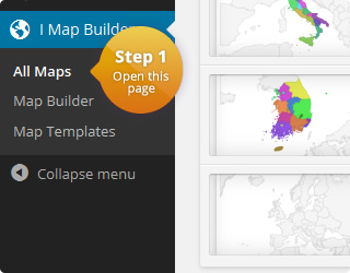
This is customized US map that shows all state names and displays HTML below the map when a text marker is clicked. You change the region of this map to create a similar map of any other country.
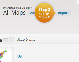
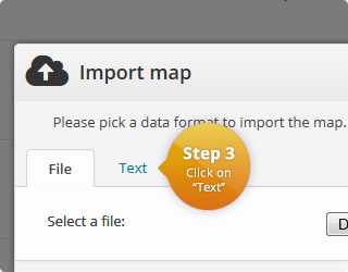
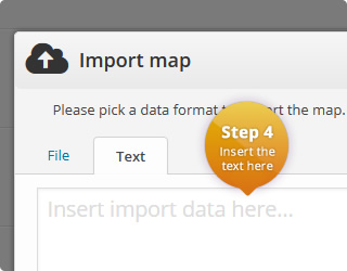
To import this map, please use the download button from below. If you want to open a link when a marker is clicked, please click on the “Map Template” bar and have a look at the JavaScript. This is the third text field. There you will already find predefined code for opening links in the same or a new window. You only have to delete the “//” in front of the corresponding line. Please don’t forget to delete or put new “//” in front of the old code. If you want to execute other actions, please send us a message and we will provide you the needed code.
If you want to activate tooltips (HTML tooltips are also possible) or want to change the font size of the text marker, you can do this in the map builder as usual.
You can also replace the text by your own. For example, you could also use abbreviations for the states:
This is the configuration of the first map:
| Name | Value | Description |
|---|---|---|
| Region | United States | List with all available regions |
| Width | auto | Width of the map in pixel. 'Auto' means that the map is centered in the available width. |
| Height | auto | Height of the map in pixel. 'Auto' means that the map is centered in the available height. |
| Display mode | Markers | Specifies the display mode of the map. |
| Border resolution | Provinces | The resolution of the map borders. |
| Tooltips | Off | Allows to display a tooltip for highlighted map elements. |
| Tooltips: Trigger | none | The user interaction that causes the tooltip to be displayed. |
| Tooltips: Use HTML | Off | Specifies if the tooltips should use HTML. This allows to customize the tooltips even more. For example, if this property is on, it is possible to display images wihtin the tooltip. |
| CSS | #{cssid} text {
fill: #444444;
}
#{cssid} text:hover {
fill: #428bca;
}
#{cssid} text[stroke-width="3"] {
display: none;
} |
|
| HTML | <div id="{cssid}">
%%map%%
<!-- (1) For showing HTML below the map: -->
<div class="value">
<em>Please click on one of the states.</em>
</div>
</div>
<script>
jQuery(function() {
var id = parseInt("{cssid}".substring(5));
map_generator["maps"][id]["options"]["displayMode"] = "text";
if(test_top_object_exists("default_options")) {
top["default_options"]["displayMode"] = "text";
jQuery(".color_column, li.colorpicker_parent", top.document).hide();
jQuery(".text_label", top.document).show();
jQuery("#optionbox_displaymode", top.document).hide();
jQuery("label.hide_in_textmode.hide_for_htmltooltips", top.document).hide();
jQuery("li.top_bottom > label.show_in_textmode", top.document).eq(0).show();
jQuery("br.show_in_textmode", top.document).show();
jQuery("label.show_in_textmode.hide_for_htmltooltips", top.document).show()
jQuery("#data_form_tooltip_title", top.document)
.attr("style", "display: block !important");
jQuery(".box_body .top_bottom label.hide_in_textmode.hide_for_htmltooltips")
.hide();
jQuery("small.left_space", top.document).hide();
jQuery("#template_description", top.document)
.css("color", "red")
.html('<small>Please don\'t change this template. '
+ 'It\'s highly customized for showing text at specific coordinates. '
+ 'If you want open a link or display HTML, have a look '
+ 'at the JavaScript in the last text field and follow the instructions there. '
+ 'For everything else, please send a message to '
+ "<a href=\"mailto:info@meisterpixel.com\">info@meisterpixel.com</a> "
+ 'and we will provide you the needed code. '
+ 'We usually reply within 24h.</small>');
}
});
function test_top_object_exists(name) {
try {
if(typeof top == "object" && typeof top[name] == "object") {
return true;
}
} catch(err) {
return false;
}
return false;
}
</script> |
|
|
JavaScript Executed when a marker/region is clicked. Click value can be defined for each map element. |
// Please remove the '//' in front of the corresponding line.

// (1)   For showing HTML below the map:
//       Please also uncomment the corresponding HTML.
jQuery("#" + cssid + " .value").html(click_value);

// (2)   For opening a link in a the same window:
// window.location = click_value;

// (3)   For opening a link in a new window:
// window.open(click_value); |
|
| Color | Name | Click Value |
|---|---|---|
| CA | This will be the information for California | |
| Oregon | This will be the information for Oregon | |
| Nevada | This will be the information for Nevada | |
| Alaska | This will be the information for Alaska | |
| Wenatchee, Washington | This will be the information for Washington | |
| Idaho | This will be the information for Idaho | |
| Phoenix, Arizona | This will be the information for Arizona | |
| Utah | This will be the information for Utah | |
| New Mexico | This will be the information for New Mexico | |
| Texas | This will be the information for Texas | |
| Hawaii | This will be the information for Hawaii | |
| Montana | This will be the information for Montana | |
| Wyomin | This will be the information for Wyoming | |
| Pike National Forest, Colorado | This will be the information for Colorado | |
| Nebraska | This will be the information for Nebraska | |
| Great Bend, Kansas | This will be the information for Kansas | |
| Oklahoma | This will be the information for Oklahoma | |
| Pierre, South Dakota | This will be the information for South Dakota | |
| North Dakota | This will be the information for North Dakota | |
| Minnesota | This will be the information for Minnesota | |
| Stevens Point, Wisconsin | This will be the information for Wisconsin | |
| Ames, Iowa | This will be the information for Iowa | |
| MIssouri | This will be the information for Missouri | |
| Illinois | This will be the information for Illinois | |
| Indianapolis, Indiana | This will be the information for Indiana | |
| Ohio | This will be the information for Ohio | |
| Lansing, Michigan | This will be the information for Michigan | |
| Brookville, Pennsylvania | This will be the information for Pennsylvania | |
| Rochester, New York | This will be the information for New York | |
| Fairlee, Vermont | This will be the information for Vermont | |
| Maine | This will be the information for Maine | |
| Isles of Shoals, New Hampshire | This will be the information for New Hampshire | |
| 41.034668, -72.608764 | This will be the information for Connecticut | |
| Massachusetts | This will be the information for Massachusetts | |
| Rhode Island | This will be the information for Rhode Island | |
| Florida | This will be the information for Florida | |
| Georgia | This will be the information for Georgia | |
| Birmingham, Alabama | This will be the information for Alabama | |
| Louisiana | This will be the information for Louisiana | |
| Mississippi | This will be the information for Mississippi | |
| Myrtle Beach, South Carolina | This will be the information for South Carolina | |
| North Carolina | This will be the information for North Carolina | |
| Nashville, Tennessee | This will be the information for Tennessee | |
| Elizabethtown, Kentucky | This will be the information for Kentucky | |
| Virginia | This will be the information for Virginia | |
| Arbuckle, WV, USA | This will be the information for West Virginia | |
| Delaware | This will be the information for Delaware | |
| Washington D.C. | This will be the information for DC | |
| New Jersey | This will be the information for New Jersey | |
| Elkton, Maryland | This will be the information for Maryland | |
| Arkansas | This will be the information for Arkansas |
This is the configuration of the second map:
| Name | Value | Description |
|---|---|---|
| Region | United States | List with all available regions |
| Width | auto | Width of the map in pixel. 'Auto' means that the map is centered in the available width. |
| Height | auto | Height of the map in pixel. 'Auto' means that the map is centered in the available height. |
| Display mode | Markers | Specifies the display mode of the map. |
| Border resolution | Provinces | The resolution of the map borders. |
| Tooltips | Off | Allows to display a tooltip for highlighted map elements. |
| Tooltips: Trigger | none | The user interaction that causes the tooltip to be displayed. |
| Tooltips: Use HTML | Off | Specifies if the tooltips should use HTML. This allows to customize the tooltips even more. For example, if this property is on, it is possible to display images wihtin the tooltip. |
| CSS | #{cssid} text {
fill: #444444;
}
#{cssid} text:hover {
fill: #428bca;
}
#{cssid} text[stroke-width="3"] {
display: none;
} |
|
| HTML | <div id="{cssid}">
%%map%%
<!-- (1) For showing HTML below the map: -->
<div class="value">
<em>Please click on one of the states.</em>
</div>
</div>
<script>
jQuery(function() {
var id = parseInt("{cssid}".substring(5));
map_generator["maps"][id]["options"]["displayMode"] = "text";
if(test_top_object_exists("default_options")) {
top["default_options"]["displayMode"] = "text";
jQuery(".color_column, li.colorpicker_parent", top.document).hide();
jQuery(".text_label", top.document).show();
jQuery("#optionbox_displaymode", top.document).hide();
jQuery("label.hide_in_textmode.hide_for_htmltooltips", top.document).hide();
jQuery("li.top_bottom > label.show_in_textmode", top.document).eq(0).show();
jQuery("br.show_in_textmode", top.document).show();
jQuery("label.show_in_textmode.hide_for_htmltooltips", top.document).show()
jQuery("#data_form_tooltip_title", top.document)
.attr("style", "display: block !important");
jQuery(".box_body .top_bottom label.hide_in_textmode.hide_for_htmltooltips")
.hide();
jQuery("small.left_space", top.document).hide();
jQuery("#template_description", top.document)
.css("color", "red")
.html('<small>Please don\'t change this template. '
+ 'It\'s highly customized for showing text at specific coordinates. '
+ 'If you want open a link or display HTML, have a look '
+ 'at the JavaScript in the last text field and follow the instructions there. '
+ 'For everything else, please send a message to '
+ "<a href=\"mailto:info@meisterpixel.com\">info@meisterpixel.com</a> "
+ 'and we will provide you the needed code. '
+ 'We usually reply within 24h.</small>');
}
});
function test_top_object_exists(name) {
try {
if(typeof top == "object" && typeof top[name] == "object") {
return true;
}
} catch(err) {
return false;
}
return false;
}
</script> |
|
|
JavaScript Executed when a marker/region is clicked. Click value can be defined for each map element. |
// Please remove the '//' in front of the corresponding line.

// (1)   For showing HTML below the map:
//       Please also uncomment the corresponding HTML.
jQuery("#" + cssid + " .value").html(click_value);

// (2)   For opening a link in a the same window:
// window.location = click_value;

// (3)   For opening a link in a new window:
// window.open(click_value); |
|
| Color | Name | Click Value |
|---|---|---|
| CA | This will be the information for California | |
| Oregon | This will be the information for Oregon | |
| Nevada | This will be the information for Nevada | |
| Alaska | This will be the information for Alaska | |
| Wenatchee, Washington | This will be the information for Washington | |
| Idaho | This will be the information for Idaho | |
| Phoenix, Arizona | This will be the information for Arizona | |
| Utah | This will be the information for Utah | |
| New Mexico | This will be the information for New Mexico | |
| Texas | This will be the information for Texas | |
| Hawaii | This will be the information for Hawaii | |
| Montana | This will be the information for Montana | |
| Wyomin | This will be the information for Wyoming | |
| Pike National Forest, Colorado | This will be the information for Colorado | |
| Nebraska | This will be the information for Nebraska | |
| Great Bend, Kansas | This will be the information for Kansas | |
| Oklahoma | This will be the information for Oklahoma | |
| Pierre, South Dakota | This will be the information for South Dakota | |
| North Dakota | This will be the information for North Dakota | |
| Minnesota | This will be the information for Minnesota | |
| Stevens Point, Wisconsin | This will be the information for Wisconsin | |
| Ames, Iowa | This will be the information for Iowa | |
| MIssouri | This will be the information for Missouri | |
| Illinois | This will be the information for Illinois | |
| Indianapolis, Indiana | This will be the information for Indiana | |
| Ohio | This will be the information for Ohio | |
| Lansing, Michigan | This will be the information for Michigan | |
| Pennsylvania | This will be the information for Pennsylvania | |
| Lebanon, NY | This will be the information for New York | |
| Vermont | This will be the information for Vermont | |
| Maine | This will be the information for Maine | |
| New Hampshire | This will be the information for New Hampshire | |
| 41.034668, -72.608764 | This will be the information for Connecticut | |
| Massachusetts | This will be the information for Massachusetts | |
| Rhode Island | This will be the information for Rhode Island | |
| Florida | This will be the information for Florida | |
| Georgia | This will be the information for Georgia | |
| Alabama | This will be the information for Alabama | |
| Louisiana | This will be the information for Louisiana | |
| Mississippi | This will be the information for Mississippi | |
| South Carolina | This will be the information for South Carolina | |
| North Carolina | This will be the information for North Carolina | |
| Tennessee | This will be the information for Tennessee | |
| Kentucky | This will be the information for Kentucky | |
| Virginia | This will be the information for Virginia | |
| WV, USA | This will be the information for West Virginia | |
| Delaware | This will be the information for Delaware | |
| Washington D.C. | This will be the information for DC | |
| 39.884265, -73.138098 | This will be the information for New Jersey | |
| Elkton, Maryland | This will be the information for Maryland | |
| Arkansas | This will be the information for Arkansas |
Comments
If you need help or have questions, please leave a comment.