This is a sample map of the USA created with our Interactive Map Builder.
You can choose an individual color and tooltip for each state on the US map. The plugin also allows to capture click events and to run custom JavaScript code. Like in the sample map, it is possible to show additional HTML content below the map. This is especially useful if the content is too large to be displayed in a tooltip. It is also possible to run your own JavaScript code if the user clicks on a region. For example, this could allow to open a lightbox or to send the user to another page.
You can also use markers instead of highlighted regions. These are often useful if you want to highlight certain points on a map, like stores and cities. Like the regions, each marker can have its own color and tooltip.
Another mode allows to use text markers. This mode was introduced in version 2.0. It allows to place text markers on the map. You can find some samples on the map example page.
This is how administration panel looks like:

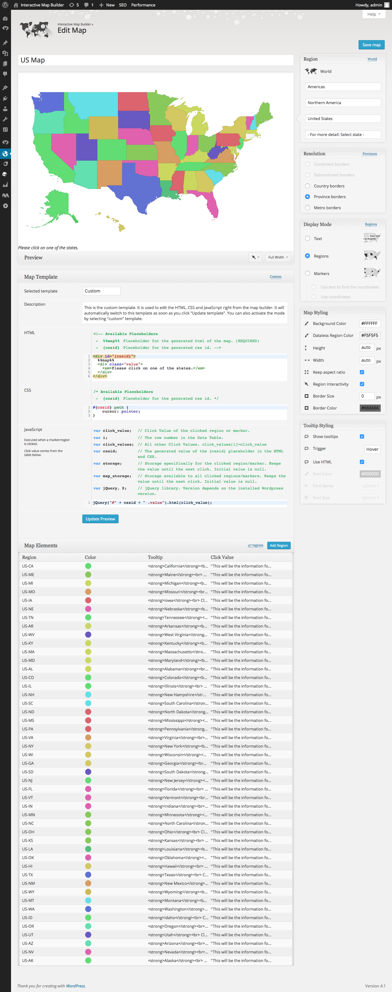
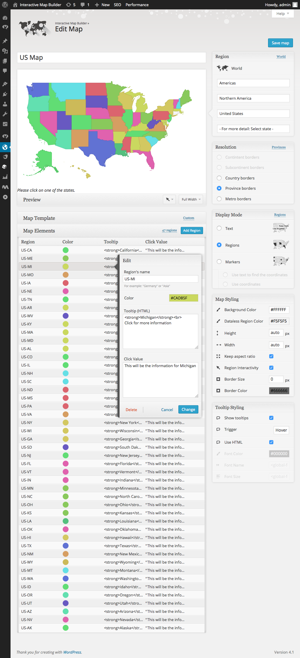
The map configuration can be found here:
| Name | Value | Description |
|---|---|---|
| Region | United States | List with all available regions |
| Width | auto | Width of the map in pixel. 'Auto' means that the map is centered in the available width. |
| Height | auto | Height of the map in pixel. 'Auto' means that the map is centered in the available height. |
| Display mode | Regions | Specifies the display mode of the map. |
| Border resolution | Provinces | The resolution of the map borders. |
| Tooltips | On | Allows to display a tooltip for highlighted map elements. |
| Tooltips: Trigger | focus | The user interaction that causes the tooltip to be displayed. |
| Tooltips: Use HTML | On | Specifies if the tooltips should use HTML. This allows to customize the tooltips even more. For example, if this property is on, it is possible to display images wihtin the tooltip. |
| CSS | #{cssid} path {
cursor: pointer;
} |
|
| HTML | <div id="{cssid}">
%%map%%
<div class="value">
<em>Please click on one of the states.</em>
</div>
</div> |
|
|
JavaScript Executed when a marker/region is clicked. Click value can be defined for each map element. |
jQuery("#" + cssid + " .value").html(click_value); |
|
| Color | Name | Click Value |
|---|---|---|
| US-AK | This will be the information for Alaska | |
| US-NV | This will be the information for Nevada | |
| US-AZ | This will be the information for Arizona | |
| US-UT | This will be the information for Utah | |
| US-OR | This will be the information for Oregon | |
| US-ID | This will be the information for Idaho | |
| US-WA | This will be the information for Washington | |
| US-MT | This will be the information for Montana | |
| US-WY | This will be the information for Wyoming | |
| US-NM | This will be the information for New Mexico | |
| US-TX | This will be the information for Texas | |
| US-HI | This will be the information for Hawaii | |
| US-OK | This will be the information for Oklahoma | |
| US-LA | This will be the information for Louisiana | |
| US-KS | This will be the information for Kansas | |
| US-OH | This will be the information for Ohio | |
| US-NC | This will be the information for North Carolina | |
| US-MN | This will be the information for Minnesota | |
| US-IN | This will be the information for Indiana | |
| US-VT | This will be the information for Vermont | |
| US-FL | This will be the information for Florida | |
| US-NJ | This will be the information for New Jersey | |
| US-SD | This will be the information for South Dakota | |
| US-GA | This will be the information for Georgia | |
| US-WI | This will be the information for Wisconsin | |
| US-NY | This will be the information for New York | |
| US-VA | This will be the information for Virginia | |
| US-PA | This will be the information for Pennsylvania | |
| US-MS | This will be the information for Mississippi | |
| US-ND | This will be the information for North Dakota | |
| US-SC | This will be the information for South Carolina | |
| US-NH | This will be the information for New Hampshire | |
| US-IL | This will be the information for Illinois | |
| US-CO | This will be the information for Colorado | |
| US-AL | This will be the information for Alabama | |
| US-MD | This will be the information for Maryland | |
| US-MA | This will be the information for Massachusetts | |
| US-KY | This will be the information for Kentucky | |
| US-WV | This will be the information for West Virginia | |
| US-AR | This will be the information for Arkansas | |
| US-TN | This will be the information for Tennessee | |
| US-NE | This will be the information for Nebraska | |
| US-IA | This will be the information for Iowa | |
| US-MO | This will be the information for Missouri | |
| US-MI | This will be the information for Michigan | |
| US-ME | This will be the information for Maine | |
| US-CA | This will be the information for California |
Comments
If you need help or have questions, please leave a comment.